La Caracola
- Ideale perShortboard, Longboard
- LivelloIntermedio
- Tipo di spotPiatto
- AffollamentoTranquillo
Queste informazioni sullo spot sono assistite dall'AI e non sono state verificate da una persona. Potrebbero essere incomplete, obsolete o imprecise. Verifica sicurezza, accesso, regole locali e condizioni attuali con fonti ufficiali o locali prima di andare in acqua.
Le informazioni localizzate sullo spot sono in preparazione. Per ora stai vedendo i contenuti in inglese.
Info
La Caracola is an exposed Caribbean beach break known for producing consistent surf, including both left and right-hand waves. Surf conditions are typically most favorable when a northeast swell lines up with southwest winds acting offshore, which helps keep the water cleaner. Autumn and winter are repeatedly identified as the optimum season for waves. While it’s described as working across tide stages (with one source emphasizing mid tide), conditions can vary with swell size; on very large swells, the break may close out due to its exposed nature. Safety is a key consideration: strong rip currents and lateral drift are reported hazards, and there are also private access restrictions that can affect where you can enter and launch. Plan your approach carefully, avoid pushing your limits in heavy currents, and respect any access rules posted at the beach. The water is reported as very warm year-round (around the high 20s °C), and crowding is generally expected to be low. Medical facilities are in Santa Marta, and no formal rescue or lifeguard presence is indicated.
- Offshore cleanup reported with southwest winds
- Consistent exposed beach break
- Low crowding even when surf is active
- Very warm water year-round
- Exposed beach break with consistent surf
- Best conditions reported when a northeast swell combines with southwest offshore winds
- Usually unlikely to be too crowded even when surf is up
- Water is very warm year-round
- Rips and strong lateral drift are reported hazards
- Private access restrictions at the beach
- No formal lifeguard presence indicated
Vento, acqua e stagioni
Vento
- Direzione
- SW
- Direzioni offshore
- SW
- Direzioni da evitare
- SW
- Intervallo del vento
- 12–22 kts
- Tipo di vento
- Aliseo — Prevailing Caribbean trade winds (Los Alisios), reinforced by local thermal effects.
- Affidabilità
- medium
- Fattore raffiche
- Raffiche leggere
- Mesi migliori
- Dicembre, Gennaio, Febbraio, Marzo, Giugno, Luglio
- Finestra termica
- Altro · Pomeriggio · +0 kts · Mesi: Gen, Feb, Mar, Dic · Dir: E, ENE, NE · Thermal reinforcement strongest roughly late morning into afternoon (about 11am–6pm).
Acqua e spiaggia
- Tipo d’acqua
- Piatto
- Spiaggia
- Sabbia
- Dimensione della spiaggia
- Medio
- Onde
- Piccolo — Also described as providing consistent surf; working swell height reported as 0.5–1.5 meters.
- Decollo
- Medio — Spacious sandy beach with enough room for boards, though mostly used for surfing.
- Difficoltà di decollo
- Moderato — Moderate launch difficulty reported.
Durante l’anno
Generally quiet; rarely crowded even when the surf is good.
May through November (heaviest rainfall typically in October and November).
Per sport
Cosa aspettarti per ognuno.
An exposed, quite consistent beach break with left and right-hand waves, best when northeast swells combine with southwest offshore winds. Works at all tide stages; best surf reported in autumn and winter.
- Direzione dell’onda
- Entrambi
- Swell ottimale
- NE
- Altezza swell
- 0.5–1.5 m
- Marea ottimale
- Tutte le maree, Medio — Providers differ on tide emphasis; one source says it works at all tide stages, while another notes best with mid tide.
- Riparo
- Esposto
- Effetto del vento
- Southwest winds are optimal as they provide offshore conditions that clean up the swell.
- Swell più grande
- On very large swells it can close out due to the exposed nature.
- Qualità dell’onda
- Discreto
- Potenza dell’onda
- Moderato
- Forma dell’onda
- Morbida
- Velocità di peeling
- Medio
- Durata della sessione
- Corto — Typically short to medium rides on the sandbars.
- Dettagli sulla lunghezza della sessione
- Waves typically provide short to medium rides on the sandbars.
Controlla le previsioni prima di andare
Vedi vento, onde, meteo e finestre di sessione per La Caracola nella vista previsioni completa.
Riepilogo delle previsioni di vento e onde per La Caracola
- Vento
- 4–9 ktsRaffiche 20 kts
- Direzione
- E95°
- Giorno più forte
- ven 20 nov9 kts
- Giorni ventosi
- 0/712 kts o più
- Onde
- 0.9–1.3 mperiodo 6s
- Temperatura
- 26–31 °C
Nei prossimi 7 giorni, per La Caracola sono previsti venti diurni di 4–9 kts, con un picco intorno a 9 kts il venerdì 20 novembre e raffiche fino a 20 kts. La direzione prevalente è E. Le onde saranno tra 0.9–1.3 m con un periodo di circa 6s. Basato sul modello Wavind, nell'ora locale dello spot.
Altri spot nella zona
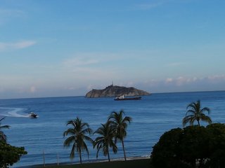
CA3avellaneda
Playa en Santa Marta, Colombia, sept 2024 · CA3avellanedaCC BY-SA 4.0FonteRidimensionataCosa sapere prima di uscire
Sicurezza, accesso, restrizioni, soccorso e regole locali possono cambiare. Considera questi dettagli come informativi e confermali localmente prima del decollo.
Pericoli
- Rips (rip currents) and strong lateral drift
- Private access restrictions
- Strong currents
- Sun exposure
Soccorso e supporto
- Bagnino
- Nessuno
- Soccorso e auto-soccorso
- Limitato — No formal coast guard or public rescue service indicated; safety depends on local sport schools and nearby eco-hostels.
- Info di emergenza
- Nearest major medical facilities are in Santa Marta; national emergency number is 123.
- Localismo / vibe
- Nessuno
Regole dello spot
Respect private access restrictions at the beach and follow general surfing etiquette. Avoid launching/entering from areas with restricted access.
- Private access restrictions at the beach
- Watch for strong rip currents that can pull you away from your entry point.
- Expect the spot to have strong currents; position carefully and surf within your limits.
Come arrivare e accesso
- Città più vicina
- Santa Marta
- Paese più vicino
- Guachaca
- Aeroporto più vicino
- Simón Bolívar International Airport (SMR) in Santa Marta
- Parcheggio
- Limited roadside parking or parking at nearby hostels and ecological lodges.
- Trasporti pubblici
- Frequent local buses and shared vans (colectivos) run along the Troncal del Caribe highway between Santa Marta and Palomino.
- Accesso
- Watch out for private access restrictions at the beach; access is via the Troncal del Caribe highway (Route 90) between Santa Marta and Palomino.
- Lingua locale
- Spanish
Cosa trovi in spiaggia
- Alloggio
- Paese vicino — Eco-hostels, hostels, and campgrounds are within walking distance along the coast.
- Cibo e bevande
- Local food stalls and small restaurants are available in nearby areas (Guachaca and Mendihuaca).
- Noleggio attrezzatura:
- Basic surfing equipment is available for rent at major beach hostels and specialized schools; dedicated surf shops are scarce.
- Deposito attrezzatura
- Limited storage is typically offered to guests staying at primary sport-focused accommodation.
- Riparazione attrezzatura
- Major kite/wing repairs are generally limited and may require travel; minor surf repairs may be possible locally.
Per questo spot non sono ancora elencate scuole o servizi.
Fuori dall'acqua
A tropical coastline area where the Sierra Nevada de Santa Marta rises near the sea, known for warm water and an eco-focused backpacker scene around riding and nature-based activities.
Protected area featuring biodiversity, palm-shaded coves, and coastal lagoons.
Archaeological site of an ancient Tayrona city in the Sierra Nevada mountains.
Float the Buritaca river through the jungle until it meets the sea.
Beachside seafood and tropical fare.
Natural pools and waterfalls ideal for swimming.
Da rider che sono stati qui
Ultime condizioni segnalate
Domande sullo spot
Domande frequenti
Qual è la stagione migliore a La Caracola?
I mesi migliori in assoluto a La Caracola sono Gennaio, Febbraio, Marzo, Dicembre. I mesi migliori per il vento sono Dicembre, Gennaio, Febbraio, Marzo, Giugno, Luglio.
Quali direzioni del vento funzionano a La Caracola?
La Caracola funziona con venti da SW. Le direzioni offshore sono SW. Le direzioni da evitare sono SW.
Per quale livello è adatto La Caracola?
La Caracola è adatto a questi livelli di riding: Surfing: Intermedio.